Cyclocane
( cyclocane is a CYCLOne and hurriCANE tracker by hayley )


English Español Deutsch Français 日本語
This storm is unnamed. If the information appears to be out of date, its name may have changed, so visit the main page for the latest information.
SIXTEEN-E Current Status
...DEPRESSION BECOMING BETTER ORGANIZED WHILE MOVING NORTH-NORTHWESTWARD... ...TROPICAL STORM CONDITIONS EXPECTED ALONG THE MEXICAN COAST TOMORROW...
Current Wind Speed 30 knots / 35 MPH
Max Predicted Wind Speed 45 knots / 50 MPH at

SIXTEEN-E Land Hazards
- RAINFALL - Tropical Depression Sixteen-E is expected to produce rainfall totals of 4 to 8 inches with local maxima of 12 inches through Tuesday across the states of Guerrero, Michoacan and the coastal sections of western Oaxaca in southwest Mexico. These rains will likely produce flash and urban flooding, along with possible mudslides in areas of higher terrain near the coast.
- WIND - Tropical storm conditions are expected to first reach the coast within the warning area on Monday, making outside preparations difficult or dangerous.
SIXTEEN-E Tracker
SIXTEEN-E Satellite Loop

SIXTEEN-E Alternate Tracking Map
SIXTEEN-E Spaghetti Models
Spaghetti models for SIXTEEN-E can be found here:
SIXTEEN-E spaghetti models page »
SIXTEEN-E Watches and Warnings
Tropical Depression SIXTEEN-E Tropical Cyclone Update
Tropical Depression SIXTEEN-E Public Advisory
000
WTPZ31 KNHC 082358
TCPEP1

BULLETIN
Tropical Depression Sixteen-E Intermediate Advisory Number 4A
NWS National Hurricane Center Miami FL       EP162023
700 PM CDT Sun Oct 08 2023

...DEPRESSION BECOMING BETTER ORGANIZED WHILE MOVING
NORTH-NORTHWESTWARD...
...TROPICAL STORM CONDITIONS EXPECTED ALONG THE MEXICAN COAST
TOMORROW...


SUMMARY OF 700 PM CDT...0000 UTC...INFORMATION
----------------------------------------------
LOCATION...16.1N 101.9W
ABOUT 110 MI...175 KM SSW OF ZIHUATANEJO MEXICO
MAXIMUM SUSTAINED WINDS...35 MPH...55 KM/H
PRESENT MOVEMENT...NNW OR 340 DEGREES AT 5 MPH...7 KM/H
MINIMUM CENTRAL PRESSURE...1005 MB...29.68 INCHES


WATCHES AND WARNINGS
--------------------
CHANGES WITH THIS ADVISORY:

None.

SUMMARY OF WATCHES AND WARNINGS IN EFFECT:

A Tropical Storm Warning is in effect for...
* Acapulco to Punta San Telmo

A Tropical Storm Warning means that tropical storm conditions are
expected somewhere within the warning area, in this case in the
next 24 hours.

For storm information specific to your area, please monitor
products issued by your national meteorological service.


DISCUSSION AND OUTLOOK
----------------------
At 700 PM CDT (0000 UTC), the center of Tropical Depression
Sixteen-E was located near latitude 16.1 North, longitude 101.9
West. The depression is moving toward the north-northwest near 5 mph
(7 km/h), and a gradual turn northward and then north-northeastward
is expected on Monday. On the forecast track, the center of the
depression is forecast to reach the coast of southern Mexico within
the warning area by late Monday.

Maximum sustained winds are near 35 mph (55 km/h) with higher
gusts. Strengthening is forecast during the next 24 hours, and the
system is forecast to become a tropical storm tonight. Rapid
weakening is expected after the system moves inland on Tuesday.

The estimated minimum central pressure is 1005 mb (29.68 inches).


HAZARDS AFFECTING LAND
----------------------
Key messages for the disturbance can be found in the Tropical
Cyclone Discussion under AWIPS header MIATCDEP1 and WMO header
WTPZ41 KNHC and on the web at hurricanes.gov/text/MIATCDEP1.shtml

RAINFALL:  Tropical Depression Sixteen-E is expected to produce
rainfall totals of 4 to 8 inches with local maxima of 12 inches
through Tuesday across the states of Guerrero, Michoacan and the
coastal sections of western Oaxaca in southwest Mexico. These rains
will likely produce flash and urban flooding, along with possible
mudslides in areas of higher terrain near the coast.

WIND:  Tropical storm conditions are expected to first reach the
coast within the warning area on Monday, making outside preparations
difficult or dangerous.


NEXT ADVISORY
-------------
Next complete advisory at 1000 PM CDT.

$$
Forecaster Hogsett/Brown
Public Advisory not available for this storm.
Tropical Depression SIXTEEN-E Forecast Discussion
000
WTPZ41 KNHC 082039
TCDEP1

Tropical Depression Sixteen-E Discussion Number   4
NWS National Hurricane Center Miami FL       EP162023
400 PM CDT Sun Oct 08 2023

Since the prior advisory, 1-minute visible images from the GOES-18
mesosector have been quite helpful in showing that the system we
have been monitoring just south of Zihuatanejo has developed a
well-defined circulation located a bit farther northwest of previous
estimations. This circulation was farther supported by a 1702 UTC
GMI pass which showed tightly curved bands wrapping most of the way
around this apparent center on the 37 GHz channel. Thus, the system
now can be considered a tropical depression, and the initial
intensity is 30 kt for this advisory, which is in between the
T1.5/25-kt estimates from TAFB and SAB versus 35-kt from the D-PRINT
estimate from UW-CIMSS.

Now that the center has become well-defined, it has formed farther
northwest than earlier estimated. This should not be considered an
acceleration in the short-term motion though, which still appears to
be slowly off to the north-northwest at 340/4 kt. This slow motion
is expected to continue with a gradual turn northward and then
north-northeastward as the system is steered around mid-level
ridging located east of it over the Caribbean Sea in addition to the
outer circulation of Tropical Storm Lidia to its west. Given the
farther northwestward initial position, the timing for landfall has
moved up a bit to between 24-36 h, by tomorrow evening. There
continues to be some spread in this landfall timing, with the GFS
remaining on the faster end versus the slower CMC and ECMWF
solutions. The latest NHC track forecast more or less splits the
difference, which is close to both the TVCE and HCCA consensus aids,
though most of the guidance now agrees the system should be inland
after 36 hours.

Intensification is still forecast up until the system moves inland
over Mexico. With landfall now between 24-36 h, there might not be
quite as much time for intensification as previously expected. With
that said, both the raw model output from the ECMWF and CMC suggest
significant intensification over the next 24 hours before the
depression makes landfall, and out of respect of these models, a
peak intensity of 45 kt continues to be shown just before landfall.
This is on the higher end of the intensity guidance envelope. The
system should quickly weaken after moving inland, ultimately
dissipating over the higher rugged terrain of south-central Mexico
by 48 hours. However, the significant up-slope flow that will result
is anticipated to continue producing very heavy rainfall into
Tuesday over coastal and inland Mexico as the cyclone and its
remnants move farther inland.


Key Messages:

1. The depression is expected to become a tropical storm before it
approaches the coast of southern Mexico on Monday.  A Tropical Storm
Warning remains in effect for a portion of the coast of southern
Mexico.

2. Heavy rains from this system will likely produce flash and urban
flooding, along with possible mudslides in areas of higher terrain
across the states of Guerrero, Michoacan and coastal sections of
western Oaxaca.


FORECAST POSITIONS AND MAX WINDS

INIT  08/2100Z 15.9N 101.7W   30 KT  35 MPH
 12H  09/0600Z 16.5N 101.8W   35 KT  40 MPH
 24H  09/1800Z 17.2N 101.7W   45 KT  50 MPH
 36H  10/0600Z 18.0N 101.4W   30 KT  35 MPH...INLAND
 48H  10/1800Z...DISSIPATED

$$
Forecaster Papin
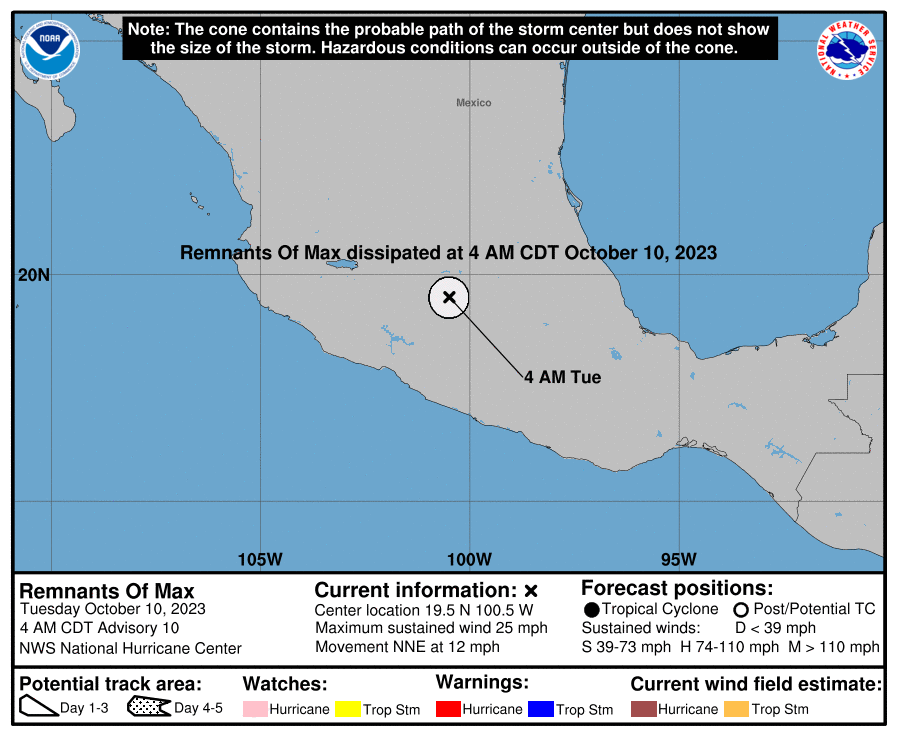
SIXTEEN-E storm path from NHC
| Time | Speed | Location | Status |
|---|---|---|---|
| 30 knots | 16.1, -101.9 | ||
| 35 knots | 16.5, -101.8 | ||
| 45 knots | 17.2, -101.7 | ||
| 30 knots | 18.0, -101.4 | translation missing: en.INLAND | |
| 0 knots | translation missing: en.DISSIPATED |
site by Hayley Croft
Want to help support this site?
- Tell your friends about Cyclocane
- make a donation - totally optional but completely appreciated
Make a monthly donation or a one-time donation to help support ongoing costs with Cyclocane.
Play solitaire and track all of the cyclocane storms at the same time at Hurricane Solitaire.