Cyclocane
( cyclocane is a CYCLOne and hurriCANE tracker by hayley )


English Español Deutsch Français 日本語
This is the final warning / advisory for this storm as it has weakened below warning levels and/or the storm system is no longer a tropical cyclone.
PHILIPPE Current Status
Current Wind Speed 45 knots / 50 MPH
Max Predicted Wind Speed 50 knots / 60 MPH at

Current Watches/Warnings / Radar / Satellite
current US watches/warnings

live tornado/thunderstorm tracker - tornadohq
future radar imagery - my future radar

future radar imagery

(above image is an example of the Western North Atlantic page - see Atlantic future radar page for a full set of images)
If a tropical storm or hurricane is threatening land, you can check my future radar for an idea of what radar might look like as the storm approaches.
PHILIPPE Land Hazards
NWS Local Hurricane Statements
- No warnings
- WIND - Strong winds are possible over portions of Atlantic Canada and eastern New England this weekend.
- RAINFALL - Rainfall will be diminishing across Bermuda today. An additional inch or less of rainfall is possible.
- SURF - Large swells will continue to affect Bermuda for the next few days. Swells are also affecting portions of the southeastern U.S. coast and will spread northward along the east coast to Atlantic Canada during the next couple of days. These conditions are likely to cause life-threatening surf and rip currents. Please consult products from your local weather office.
PHILIPPE Tracker
PHILIPPE Satellite Loop
PHILIPPE Alternate Tracking Map
PHILIPPE Spaghetti Models
Spaghetti models for PHILIPPE can be found here:
PHILIPPE spaghetti models page »
PHILIPPE Watches and Warnings
Post-Tropical Cyclone PHILIPPE Tropical Cyclone Update
Post-Tropical Cyclone PHILIPPE Public Advisory
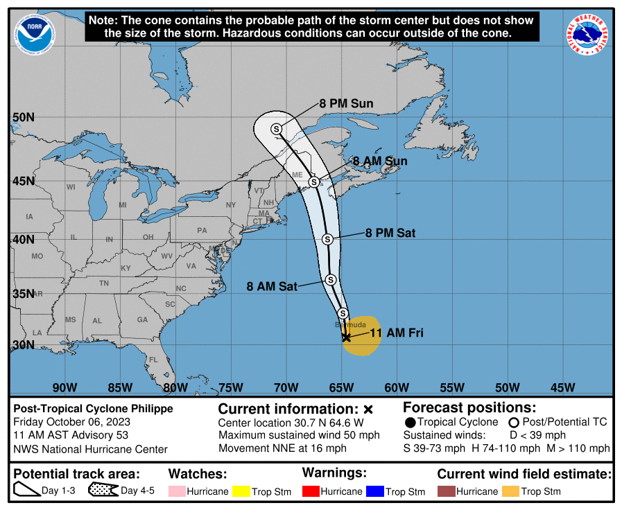
000
WTNT32 KNHC 061453
TCPAT2

BULLETIN
Post-Tropical Cyclone Philippe Advisory Number  53
NWS National Hurricane Center Miami FL       AL172023
1100 AM AST Fri Oct 06 2023

...PHILIPPE BECOMES POST-TROPICAL BUT STILL POSES A RISK OF FLASH
FLOODING ACROSS NEW ENGLAND THIS WEEKEND...
...THIS IS THE LAST NHC ADVISORY...


SUMMARY OF 1100 AM AST...1500 UTC...INFORMATION
-----------------------------------------------
LOCATION...30.7N 64.6W
ABOUT 110 MI...180 KM S OF BERMUDA
MAXIMUM SUSTAINED WINDS...50 MPH...85 KM/H
PRESENT MOVEMENT...NNE OR 20 DEGREES AT 16 MPH...26 KM/H
MINIMUM CENTRAL PRESSURE...1003 MB...29.62 INCHES


WATCHES AND WARNINGS
--------------------
CHANGES WITH THIS ADVISORY:

The Bermuda Weather Service has discontinued the Tropical Storm
Warning for Bermuda.

SUMMARY OF WATCHES AND WARNINGS IN EFFECT:

There are no coastal watches or warnings in effect.

Interests in eastern New England and Atlantic Canada should monitor
the progress of the post-tropical cyclone and refer to products
issued by their local weather offices.


DISCUSSION AND OUTLOOK
----------------------
At 1100 AM AST (1500 UTC), the center of Post-Tropical Cyclone
Philippe was located near latitude 30.7 North, longitude 64.6 West.
The post-tropical cyclone is moving toward the north-northeast near
16 mph (26 km/h).  A northward or north-northwestward motion at a
faster forward speed is expected during the next few days.  On the
forecast track, the system will continue passing Bermuda today and
will reach the coast of Atlantic Canada or eastern New England
Saturday night or Sunday.

Maximum sustained winds are near 50 mph (85 km/h) with higher gusts.
Some strengthening is possible over the next day or so.

Tropical-storm-force winds extend outward up to 205 miles (335 km)
to the east of the center.

The estimated minimum central pressure is 1003 mb (29.62 inches).


HAZARDS AFFECTING LAND
----------------------
Key messages for Philippe can be found in the Tropical Cyclone
Discussion under AWIPS header MIATCDAT2 and WMO header WTNT42 KNHC
and on the web at hurricanes.gov/text/MIATCDAT2.shtml

WIND:  Strong winds are possible over portions of Atlantic Canada
and eastern New England this weekend.

RAINFALL:  Rainfall will be diminishing across Bermuda today.  An
additional inch or less of rainfall is possible.

For portions of New York and New England, and Southeast Canada,
rainfall amounts of 1 to 3 inches, with local maximum amounts of 5
inches, are expected this weekend.  Isolated to scattered instances
of urban and flash flooding will be possible.

SURF:  Large swells will continue to affect Bermuda for the next
few days.  Swells are also affecting portions of the southeastern
U.S. coast and will spread northward along the east coast to
Atlantic Canada during the next couple of days.  These conditions
are likely to cause life-threatening surf and rip currents.  Please
consult products from your local weather office.


NEXT ADVISORY
-------------
This is the last public advisory issued by the National Hurricane
Center on this system.  Future information on potential flooding
from this system in the Northeast U.S. can be found in products
issued by the Weather Prediction Center on the web at
www.wpc.ncep.noaa.gov, and in products issued by local National
Weather Service Forecast offices on the web at www.weather.gov.

Additional information on marine impacts from this system can be
found in High Seas Forecasts issued by the National Weather Service,
under AWIPS header NFDHSFAT1, WMO header FZNT01 KWBC, and online at
ocean.weather.gov/shtml/NFDHSFAT1.php

$$
Forecaster Berg
Public Advisory not available for this storm.
Post-Tropical Cyclone PHILIPPE Forecast Discussion
000
WTNT42 KNHC 061454
TCDAT2

Post-Tropical Cyclone Philippe Discussion Number  53
NWS National Hurricane Center Miami FL       AL172023
1100 AM AST Fri Oct 06 2023

The center we were following overnight has become untrackable this
morning and appears to have become absorbed by the nearby frontal
zone.  In addition, the overall cloud pattern now has the look of a
classic extratropical cyclone, with Philippe's center resembling
the triple point of an occlusion.  Based on these recent
developments, Philippe is being declared a post-tropical cyclone.
The intensity remains 45 kt, mainly based on continuity.

The initial motion is estimated to be north-northeastward, or
020/14 kt, but this movement is becoming less representative as the
larger storm system takes over.  Philippe's remnant center and
another non-tropical low to the west are likely to interact and/or
merge with each other during the next day or two, but the overall
system is expected to move northward or north-northwestward at
increasing forward speed into the weekend.  This will bring the
center of the post-tropical cyclone to the coast of Nova Scotia or
Maine in about 48 hours, and then inland toward eastern Quebec
before it becomes absorbed by a separate but larger extratropical
low.

The post-tropical cyclone still has an opportunity to strengthen a
bit over the next day or so due to baroclinic influences.  Due to
the system's structure and forward motion, the strongest winds are
expected to be on the eastern side of the circulation and will
most likely affect portions of Atlantic Canada.  Weakening is
forecast after the system moves inland.

Future information on potential flooding impacts in the Northeast
United States can be found in products issued by the Weather
Prediction Center on the web at http://www.wpc.ncep.noaa.gov, and
in products issued by local National Weather Service Forecast
Offices on the web at http://weather.gov.

Additional information on marine impacts can be found in High Seas
Forecasts issued by the National Weather Service, under AWIPS
header NFDHSFAT1, WMO header FZNT01 KWBC, and online at
ocean.weather.gov/shtml/NFDHSFAT1.php.


KEY MESSAGES:

1. The post-tropical cyclone is expected to move over portions of
Atlantic Canada and New England this weekend.  Interests in those
areas should be prepared for the possibility of strong winds and
heavy rainfall and monitor statements from their local weather
office.  The rainfall may produce isolated to scattered instances of
urban and flash flooding.


FORECAST POSITIONS AND MAX WINDS

INIT  06/1500Z 30.7N  64.6W   45 KT  50 MPH...POST-TROP/EXTRATROP
 12H  07/0000Z 33.1N  64.9W   45 KT  50 MPH...POST-TROP/EXTRATROP
 24H  07/1200Z 36.3N  66.0W   50 KT  60 MPH...POST-TROP/EXTRATROP
 36H  08/0000Z 40.0N  66.3W   50 KT  60 MPH...POST-TROP/EXTRATROP
 48H  08/1200Z 44.9N  67.5W   45 KT  50 MPH...POST-TROP/INLAND
 60H  09/0000Z 49.1N  70.9W   35 KT  40 MPH...POST-TROP/INLAND
 72H  09/1200Z...DISSIPATED

$$
Forecaster Berg
PHILIPPE storm path from NHC
| Time | Speed | Location | Status |
|---|---|---|---|
| 45 knots | 30.7, -64.6 | POST-TROPICAL CYCLONE | |
| 45 knots | 33.1, -64.9 | POST-TROPICAL CYCLONE | |
| 50 knots | 36.3, -66.0 | POST-TROPICAL CYCLONE | |
| 50 knots | 40.0, -66.3 | POST-TROPICAL CYCLONE | |
| 45 knots | 44.9, -67.5 | translation missing: en.POST-TROP/INLAND | |
| 35 knots | 49.1, -70.9 | translation missing: en.POST-TROP/INLAND | |
| 0 knots | translation missing: en.DISSIPATED |
site by Hayley Croft
- Tell your friends about Cyclocane
- make a donation - totally optional but completely appreciated
Make a monthly donation or a one-time donation to help support ongoing costs with Cyclocane.
Play solitaire and track all of the cyclocane storms at the same time at Hurricane Solitaire.