Cyclocane
( cyclocane is a CYCLOne and hurriCANE tracker by hayley )


English Español Deutsch Français 日本語
This is the final warning / advisory for this storm as it has weakened below warning levels and/or the storm system is no longer a tropical cyclone.
MAX Current Status
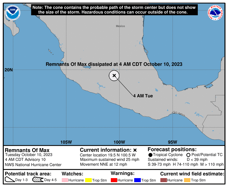
...MAX DISSIPATES OVER MEXICO... ...THIS IS THE LAST ADVISORY...
Current Wind Speed 20 knots / 25 MPH
Max Predicted Wind Speed 20 knots / 25 MPH at

MAX Land Hazards
- SURF - Swells generated by Max will affect the southern coast of Mexico today. These swells are likely to cause life-threatening surf and rip current conditions. Please consult products from your local weather office.
MAX Tracker
MAX Satellite Loop

MAX Alternate Tracking Map
MAX Spaghetti Models
Spaghetti models for MAX can be found here:
MAX Watches and Warnings
Remnants Of MAX Tropical Cyclone Update
Remnants Of MAX Public Advisory
003
WTPZ31 KNHC 100840
TCPEP1

BULLETIN
Remnants Of Max Advisory Number  10
NWS National Hurricane Center Miami FL       EP162023
400 AM CDT Tue Oct 10 2023

...MAX DISSIPATES OVER MEXICO...
...THIS IS THE LAST ADVISORY...


SUMMARY OF 400 AM CDT...0900 UTC...INFORMATION
----------------------------------------------
LOCATION...19.5N 100.5W
ABOUT 145 MI...230 KM NNE OF ZIHUATANEJO MEXICO
MAXIMUM SUSTAINED WINDS...25 MPH...40 KM/H
PRESENT MOVEMENT...NNE OR 25 DEGREES AT 12 MPH...19 KM/H
MINIMUM CENTRAL PRESSURE...1005 MB...29.68 INCHES


WATCHES AND WARNINGS
--------------------
There are no coastal watches or warnings in effect.


DISCUSSION AND OUTLOOK
----------------------
At 400 AM CDT (0900 UTC), the remnants of Max were located near
latitude 19.5 North, longitude 100.5 West. The remnants are moving
toward the north-northeast near 12 mph (19 km/h).

Maximum sustained winds are near 25 mph (40 km/h) with higher gusts.

The estimated minimum central pressure is 1005 mb (29.68 inches).


HAZARDS AFFECTING LAND
----------------------
SURF:  Swells generated by Max will affect the southern coast of
Mexico today.  These swells are likely to cause life-threatening
surf and rip current conditions.  Please consult products from your
local weather office.


NEXT ADVISORY
-------------
This is the last public advisory issued by the National Hurricane
Center on this system.

$$
Forecaster Blake
Public Advisory not available for this storm.
Remnants Of MAX Forecast Discussion
000
WTPZ41 KNHC 100841
TCDEP1

Remnants Of Max Discussion Number  10
NWS National Hurricane Center Miami FL       EP162023
400 AM CDT Tue Oct 10 2023

Satellite images show that any convection associated with Max has
weakened, and there are no signs of a well-defined surface center.
Thus this system has dissipated over the high terrain of Mexico,
and the initial wind speed is set to 20 kt in accordance with a
rapid weakening rate.  Any future rainfall from this system is not
anticipated to be significant.

This is the last advisory from the National Hurricane Center on
this system.

FORECAST POSITIONS AND MAX WINDS

INIT  10/0900Z 19.5N 100.5W   20 KT  25 MPH...REMNANTS OF
 12H  10/1800Z...DISSIPATED

$$
Forecaster Blake
MAX storm path from NHC
| Time | Speed | Location | Status |
|---|---|---|---|
| 20 knots | 19.5, -100.5 | REMNANTS OF | |
| 0 knots | translation missing: en.DISSIPATED |
site by Hayley Croft
Want to help support this site?
- Tell your friends about Cyclocane
- make a donation - totally optional but completely appreciated
Make a monthly donation or a one-time donation to help support ongoing costs with Cyclocane.
Play solitaire and track all of the cyclocane storms at the same time at Hurricane Solitaire.