Cyclocane
( cyclocane is a CYCLOne and hurriCANE tracker by hayley )


English Español Deutsch Français 日本語
This is the final warning / advisory for this storm as it has weakened below warning levels and/or the storm system is no longer a tropical cyclone.
KATIA Current Status
Current Wind Speed 30 knots / 35 MPH
Max Predicted Wind Speed 30 knots / 35 MPH at

Current Watches/Warnings / Radar / Satellite
current US watches/warnings

live tornado/thunderstorm tracker - tornadohq
future radar imagery - my future radar

future radar imagery

(above image is an example of the Western North Atlantic page - see Atlantic future radar page for a full set of images)
If a tropical storm or hurricane is threatening land, you can check my future radar for an idea of what radar might look like as the storm approaches.
KATIA Land Hazards
NWS Local Hurricane Statements
- No warnings
KATIA Tracker
KATIA Satellite Loop
KATIA Alternate Tracking Map
KATIA Spaghetti Models
Spaghetti models for KATIA can be found here:
KATIA Watches and Warnings
Post-Tropical Cyclone KATIA Tropical Cyclone Update
Post-Tropical Cyclone KATIA Public Advisory
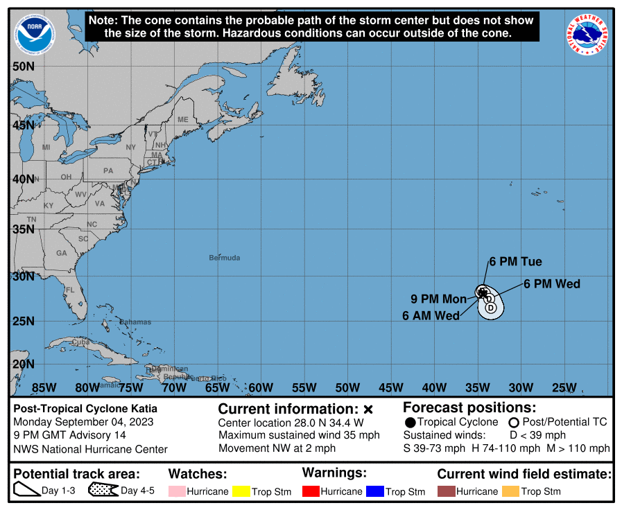
000
WTNT34 KNHC 042031
TCPAT4

BULLETIN
Post-Tropical Cyclone Katia Advisory Number  14
NWS National Hurricane Center Miami FL       AL122023
900 PM GMT Mon Sep 04 2023

...KATIA HAS COME TO THE END...
...THIS IS THE LAST NHC ADVISORY...


SUMMARY OF 900 PM GMT...2100 UTC...INFORMATION
----------------------------------------------
LOCATION...28.0N 34.4W
ABOUT 1060 MI...1710 KM NW OF THE CABO VERDE ISLANDS
MAXIMUM SUSTAINED WINDS...35 MPH...55 KM/H
PRESENT MOVEMENT...NW OR 305 DEGREES AT 2 MPH...4 KM/H
MINIMUM CENTRAL PRESSURE...1010 MB...29.83 INCHES


WATCHES AND WARNINGS
--------------------
There are no coastal watches or warnings in effect.


DISCUSSION AND OUTLOOK
----------------------
At 900 PM GMT (2100 UTC), the center of Post-Tropical Cyclone Katia
was located near latitude 28.0 North, longitude 34.4 West. The
post-tropical cyclone is moving toward the northwest near 2 mph (4
km/h). Katia should slowly undergo a clockwise loop during the next
two days and move more steadily southward by late Wednesday.

Maximum sustained winds are near 35 mph (55 km/h) with higher gusts.
The system should gradually weaken and degenerate into a trough on
Thursday.

The estimated minimum central pressure is 1010 mb (29.83 inches).


HAZARDS AFFECTING LAND
----------------------
None


NEXT ADVISORY
-------------
This is the last public advisory issued by the National Hurricane
Center on this system. Additional information on this system can be
found in High Seas Forecasts issued by Meteo France under WMO
header FQNT50 LFPW and available on the web at
www.meteofrance.com/previsions-meteo-marine/bulletin/grandlarge/
metarea2

$$
Forecaster Blake
Public Advisory not available for this storm.
Post-Tropical Cyclone KATIA Forecast Discussion
000
WTNT44 KNHC 042032
TCDAT4

Post-Tropical Cyclone Katia Discussion Number  14
NWS National Hurricane Center Miami FL       AL122023
900 PM GMT Mon Sep 04 2023

The convection clock has run out on Katia with no organized
thunderstorm activity for most of the day.  No additional organized
convection is expected either due to very dry air aloft and
continued shear. Thus, the system is declared post-tropical, and
this is the last NHC advisory. The winds are set to 30 kt in
accordance with an earlier scatterometer pass.

Katia isn't moving much now, and it is forecast to drift in a small
clockwise loop over the next day or two within the subtropical
ridge.  The remnants of the system should move a bit faster
southward on Wednesday, gradually weakening due to the unfavorable
environment, and open up into a trough within 3 days.

Additional information on this system can be found in High Seas
Forecasts issued by Meteo France under WMO header FQNT50 LFPW and
available on the web at
www.meteofrance.com/previsions-meteo-marine/bulletin/grandlarge/
metarea2.


FORECAST POSITIONS AND MAX WINDS

INIT  04/2100Z 28.0N  34.4W   30 KT  35 MPH...POST-TROP/REMNT LOW
 12H  05/0600Z 28.2N  34.7W   25 KT  30 MPH...POST-TROP/REMNT LOW
 24H  05/1800Z 28.4N  34.5W   25 KT  30 MPH...POST-TROP/REMNT LOW
 36H  06/0600Z 28.1N  34.2W   25 KT  30 MPH...POST-TROP/REMNT LOW
 48H  06/1800Z 27.5N  33.7W   20 KT  25 MPH...POST-TROP/REMNT LOW
 60H  07/0600Z 26.5N  33.5W   20 KT  25 MPH...POST-TROP/REMNT LOW
 72H  07/1800Z...DISSIPATED

$$
Forecaster Blake
KATIA storm path from NHC
| Time | Speed | Location | Status |
|---|---|---|---|
| 30 knots | 28.0, -34.4 | POST-TROPICAL CYCLONE | |
| 25 knots | 28.2, -34.7 | POST-TROPICAL CYCLONE | |
| 25 knots | 28.4, -34.5 | POST-TROPICAL CYCLONE | |
| 25 knots | 28.1, -34.2 | POST-TROPICAL CYCLONE | |
| 20 knots | 27.5, -33.7 | POST-TROPICAL CYCLONE | |
| 20 knots | 26.5, -33.5 | POST-TROPICAL CYCLONE | |
| 0 knots | translation missing: en.DISSIPATED |
site by Hayley Croft
- Tell your friends about Cyclocane
- make a donation - totally optional but completely appreciated
Make a monthly donation or a one-time donation to help support ongoing costs with Cyclocane.
Play solitaire and track all of the cyclocane storms at the same time at Hurricane Solitaire.