Cyclocane
( cyclocane is a CYCLOne and hurriCANE tracker by hayley )


English Español Deutsch Français 日本語
This is the final warning / advisory for this storm as it has weakened below warning levels and/or the storm system is no longer a tropical cyclone.
JOSE Current Status
Current Wind Speed 40 knots / 45 MPH
Max Predicted Wind Speed 40 knots / 45 MPH at

Current Watches/Warnings / Radar / Satellite
current US watches/warnings

live tornado/thunderstorm tracker - tornadohq
future radar imagery - my future radar

future radar imagery

(above image is an example of the Western North Atlantic page - see Atlantic future radar page for a full set of images)
If a tropical storm or hurricane is threatening land, you can check my future radar for an idea of what radar might look like as the storm approaches.
JOSE Land Hazards
NWS Local Hurricane Statements
- No warnings
JOSE Tracker
JOSE Satellite Loop
JOSE Alternate Tracking Map
JOSE Spaghetti Models
Spaghetti models for JOSE can be found here:
JOSE Watches and Warnings
Remnants Of JOSE Tropical Cyclone Update
Remnants Of JOSE Public Advisory
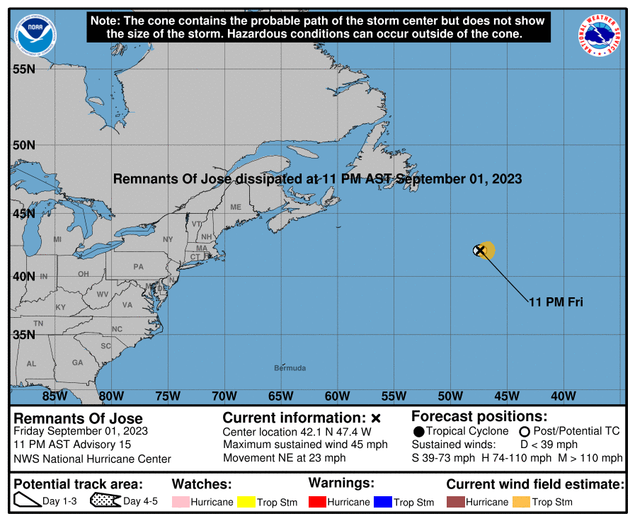
000
WTNT31 KNHC 020242
TCPAT1

BULLETIN
Remnants Of Jose Advisory Number  15
NWS National Hurricane Center Miami FL       AL112023
1100 PM AST Fri Sep 01 2023

...JOSE ABSORBED INTO POST-TROPICAL CYCLONE FRANKLIN...
...THIS IS THE LAST NHC ADVISORY...


SUMMARY OF 1100 PM AST...0300 UTC...INFORMATION
-----------------------------------------------
LOCATION...42.1N 47.4W
ABOUT 1170 MI...1880 KM NE OF BERMUDA
MAXIMUM SUSTAINED WINDS...45 MPH...75 KM/H
PRESENT MOVEMENT...NE OR 35 DEGREES AT 23 MPH...37 KM/H
MINIMUM CENTRAL PRESSURE...999 MB...29.50 INCHES


WATCHES AND WARNINGS
--------------------
There are no coastal watches or warnings in effect.


DISCUSSION AND OUTLOOK
----------------------
At 1100 PM AST (0300 UTC), the remnants of Jose were located near
latitude 42.1 North, longitude 47.4 West. The remnants are moving
toward the northeast near 23 mph (37 km/h).

Maximum sustained winds are near 45 mph (75 km/h) with higher gusts.

Tropical-storm-force winds extend outward up to 70 miles (110 km)
from the center.

The estimated minimum central pressure is 999 mb (29.50 inches).


HAZARDS AFFECTING LAND
----------------------
None


NEXT ADVISORY
-------------
This is the last public advisory issued by the National Hurricane
Center on this system.

$$
Forecaster Bucci
Public Advisory not available for this storm.
Remnants Of JOSE Forecast Discussion
000
WTNT41 KNHC 020242
TCDAT1

Remnants Of Jose Discussion Number  15
NWS National Hurricane Center Miami FL       AL112023
1100 PM AST Fri Sep 01 2023

Jose has been absorbed into the powerful extratropical cyclone,
Franklin.  Geostationary imagery suggests the remnants of Jose are
embedded in a convective band in the northeast quadrant of Franklin.
The initial intensity has been set to 40 kt, though it is hard to
determine a maximum wind speed associated with the remnants, when
the intensity of Franklin is likely much stronger.

This is the last advisory issued by the National Hurricane Center on
Jose.  Additional information on this system can be found in High
Seas Forecasts issued by the National Weather Service, under AWIPS
header NFDHSFAT1, WMO header FZNT01 KWBC, and online at
ocean.weather.gov/shtml/NFDHSFAT1.php


FORECAST POSITIONS AND MAX WINDS

INIT  02/0300Z 42.1N  47.4W   40 KT  45 MPH
 12H  02/1200Z...DISSIPATED

$$
Forecaster Bucci
JOSE storm path from NHC
| Time | Speed | Location | Status |
|---|---|---|---|
| 40 knots | 42.1, -47.4 | ||
| 0 knots | translation missing: en.DISSIPATED |
site by Hayley Croft
- Tell your friends about Cyclocane
- make a donation - totally optional but completely appreciated
Make a monthly donation or a one-time donation to help support ongoing costs with Cyclocane.
Play solitaire and track all of the cyclocane storms at the same time at Hurricane Solitaire.