Cyclocane
( cyclocane is a CYCLOne and hurriCANE tracker by hayley )


English Español Deutsch Français 日本語
This is the final warning / advisory for this storm as it has weakened below warning levels and/or the storm system is no longer a tropical cyclone.
HILARY Current Status
...CONTINUED LIFE-THREATENING AND LOCALLY CATASTROPHIC FLOODING EXPECTED OVER PORTIONS OF THE SOUTHWESTERN U.S. TODAY... ...NEXT ADVISORY TO BE ISSUED BY THE WEATHER PREDICTION CENTER...
Current Wind Speed 25 knots / 30 MPH
Max Predicted Wind Speed 25 knots / 30 MPH at

HILARY Land Hazards
- RAINFALL - Post-Tropical Hilary is expected to produce additional rainfall amounts of 2 to 4 inches, with isolated storm total amounts to 12 inches, across portions of Southern California and Southern Nevada through today. Continued flash and urban flooding, locally catastrophic, is expected.
- WIND - Post-tropical Hilary is still expected to produce strong and gusty winds in and near areas of elevated terrain today.
- SURF - Large swells will continue to affect portions of the Baja California Peninsula and southern California through this morning. These swells are likely to cause life-threatening surf and rip current conditions. Please consult products from your local weather office.
HILARY Tracker
HILARY Satellite Loop

HILARY Alternate Tracking Map
HILARY Spaghetti Models
Spaghetti models for HILARY can be found here:
HILARY spaghetti models page »
HILARY Watches and Warnings
Post-Tropical Cyclone HILARY Tropical Cyclone Update
Post-Tropical Cyclone HILARY Public Advisory
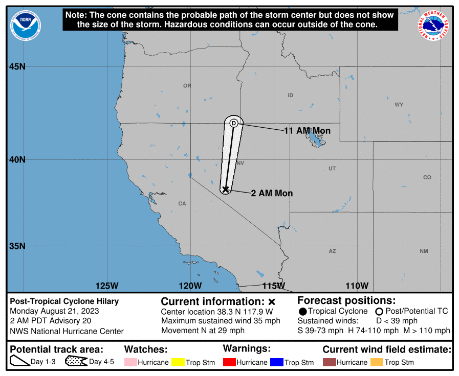
000
WTPZ34 KNHC 210846
TCPEP4

BULLETIN
Post-Tropical Cyclone Hilary Advisory Number  20
NWS National Hurricane Center Miami FL       EP092023
200 AM PDT Mon Aug 21 2023

...CONTINUED LIFE-THREATENING AND LOCALLY CATASTROPHIC FLOODING
EXPECTED OVER PORTIONS OF THE SOUTHWESTERN U.S. TODAY...
...NEXT ADVISORY TO BE ISSUED BY THE WEATHER PREDICTION CENTER...


SUMMARY OF 200 AM PDT...0900 UTC...INFORMATION
----------------------------------------------
LOCATION...38.3N 117.9W
ABOUT 390 MI...625 KM N OF SAN DIEGO CALIFORNIA
MAXIMUM SUSTAINED WINDS...35 MPH...55 KM/H
PRESENT MOVEMENT...N OR 355 DEGREES AT 29 MPH...46 KM/H
MINIMUM CENTRAL PRESSURE...1004 MB...29.65 INCHES


WATCHES AND WARNINGS
--------------------
CHANGES WITH THIS ADVISORY:

All coastal warnings have been discontinued.

SUMMARY OF WATCHES AND WARNINGS IN EFFECT:

There are no coastal watches or warnings in effect.

For storm information specific to your area in the United
States, including possible inland watches and warnings, please
monitor products issued by your local National Weather Service
forecast office. For storm information specific to your area
outside of the United States, please monitor products issued by
your national meteorological service.


DISCUSSION AND OUTLOOK
----------------------
At 200 AM PDT (0900 UTC), the center of Post-Tropical Cyclone Hilary
was located near latitude 38.3 North, longitude 117.9 West. The
post-tropical cyclone is moving toward the north near 29 mph (46
km/h), and this general motion is expected to continue today. On the
forecast track, the center of post-tropical Hilary will move quickly
across Nevada today.

Maximum sustained winds are near 35 mph (55 km/h) with higher gusts.
Post-tropical Hilary is forecast to dissipate later today.

The estimated minimum central pressure is 1004 mb (29.65 inches).


HAZARDS AFFECTING LAND
----------------------
Key messages for Hilary can be found in the Tropical Cyclone
Discussion under AWIPS header MIATCDEP4 and WMO header WTPZ44 KNHC
and on the web at hurricanes.gov/text/MIATCDEP4.shtml.

RAINFALL:  Post-Tropical Hilary is expected to produce additional
rainfall amounts of 2 to 4 inches, with isolated storm total amounts
to 12 inches, across portions of Southern California and Southern
Nevada through today. Continued flash and urban flooding, locally
catastrophic, is expected.

Across portions of Oregon and Idaho, rainfall totals of 1 to 3
inches with local maxima to 5 inches are expected through Tuesday
morning, resulting in localized, some significant, flash flooding.

A list of rainfall observations compiled by the NOAA Weather
Prediction Center for this storm can be found at:
www.wpc.ncep.noaa.gov/discussions/nfdscc4.html

WIND:  Post-tropical Hilary is still expected to produce strong and
gusty winds in and near areas of elevated terrain today.

SURF:  Large swells will continue to affect portions of the Baja
California Peninsula and southern California through this morning.
These swells are likely to cause life-threatening surf and rip
current conditions. Please consult products from your local weather
office.


NEXT ADVISORY
-------------
This is the last public advisory issued by the National Hurricane
Center on Post-tropical Hilary. Future information on this system
can be found in Public Advisories issued by the Weather Prediction
Center beginning at 800 AM PDT, under AWIPS header TCPEP4, WMO
header WTPZ34 KWNH, and on the web at www.hurricanes.gov.

$$
Forecaster Reinhart
Public Advisory not available for this storm.
Post-Tropical Cyclone HILARY Forecast Discussion
ZCZC NFDTCDEP4 ALL
TTAA00 KWNH DDHHMM

Post-Tropical Cyclone Hilary Discussion Number  22
NWS Weather Prediction Center College Park MD   EP092023
200 PM PDT Mon Aug 21 2023

KEY MESSAGES:

1. Locally heavy rains and isolated flooding impacts are possible
across northern portions of the Intermountain West into Tuesday
morning.

2. Strong, gusty winds in Nevada, western Utah, southern Idaho, and
southwest Montana. The strongest gusts will be favored in higher
terrain, passes, and canyons, as well as in proximity to
thunderstorms.

FORECAST POSITIONS AND MAX WINDS

INIT  21/2100Z 44.6N 115.5W   25 KT  30 MPH...POST-TROPICAL
 12H  22/0600Z 47.7N 111.6W   20 KT  25 MPH...DISSIPATED

$$
Carbin

NNNN
HILARY storm path from NHC
| Time | Speed | Location | Status |
|---|---|---|---|
| 25 knots | 44.6, -115.5 | translation missing: en.POST-TROPICAL | |
| 20 knots | 47.7, -111.6 | translation missing: en.DISSIPATED |
site by Hayley Croft
Want to help support this site?
- Tell your friends about Cyclocane
- make a donation - totally optional but completely appreciated
Make a monthly donation or a one-time donation to help support ongoing costs with Cyclocane.
Play solitaire and track all of the cyclocane storms at the same time at Hurricane Solitaire.