Cyclocane
( cyclocane is a CYCLOne and hurriCANE tracker by hayley )


English Español Deutsch Français 日本語
This is the final warning / advisory for this storm as it has weakened below warning levels and/or the storm system is no longer a tropical cyclone.
FRANKLIN Current Status
Current Wind Speed 70 knots / 80 MPH
Max Predicted Wind Speed 70 knots / 80 MPH at

Current Watches/Warnings / Radar / Satellite
current US watches/warnings

live tornado/thunderstorm tracker - tornadohq
future radar imagery - my future radar

future radar imagery

(above image is an example of the Western North Atlantic page - see Atlantic future radar page for a full set of images)
If a tropical storm or hurricane is threatening land, you can check my future radar for an idea of what radar might look like as the storm approaches.
FRANKLIN Land Hazards
NWS Local Hurricane Statements
- No warnings
FRANKLIN Tracker
FRANKLIN Satellite Loop
FRANKLIN Alternate Tracking Map
FRANKLIN Spaghetti Models
Spaghetti models for FRANKLIN can be found here:
FRANKLIN spaghetti models page »
FRANKLIN Watches and Warnings
Post-Tropical Cyclone FRANKLIN Tropical Cyclone Update
Post-Tropical Cyclone FRANKLIN Public Advisory
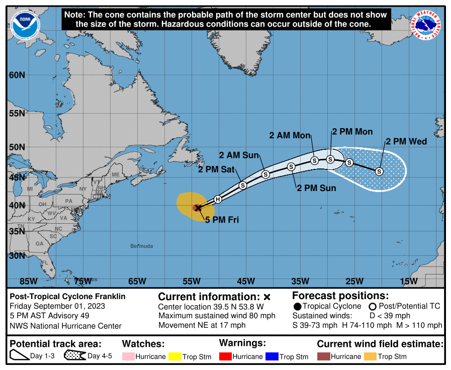
000
WTNT33 KNHC 012038
TCPAT3

BULLETIN
Post-Tropical Cyclone Franklin Advisory Number  49
NWS National Hurricane Center Miami FL       AL082023
500 PM AST Fri Sep 01 2023

...FRANKLIN HAS BECOME A POWERFUL EXTRATROPICAL CYCLONE...
...THIS IS THE FINAL NHC ADVISORY...


SUMMARY OF 500 PM AST...2100 UTC...INFORMATION
----------------------------------------------
LOCATION...39.5N 53.8W
ABOUT 790 MI...1270 KM NE OF BERMUDA
MAXIMUM SUSTAINED WINDS...80 MPH...130 KM/H
PRESENT MOVEMENT...NE OR 55 DEGREES AT 17 MPH...28 KM/H
MINIMUM CENTRAL PRESSURE...979 MB...28.91 INCHES


WATCHES AND WARNINGS
--------------------
There are no coastal watches or warnings in effect.


DISCUSSION AND OUTLOOK
----------------------
At 500 PM AST (2100 UTC), the center of Post-Tropical Cyclone
Franklin was located near latitude 39.5 North, longitude 53.8 West.
The post-tropical cyclone is moving toward the northeast near 17 mph
(28 km/h). A faster northeastward motion is expected during the
next couple of days, followed by a turn to the east-northeast.

Maximum sustained winds are near 80 mph (130 km/h) with higher
gusts. Little change in strength is expected through tonight, but
gradual weakening is forecast this weekend into early next week.

Hurricane-force winds extend outward up to 60 miles (95 km) from the
center and tropical-storm-force winds extend outward up to 255 miles
(405 km).

The estimated minimum central pressure is 979 mb (28.91 inches).


HAZARDS AFFECTING LAND
----------------------
None


NEXT ADVISORY
-------------
This is the last public advisory issued by the National Hurricane
Center on Franklin. Additional information on this system can be
found in High Seas Forecasts issued by the National Weather Service,
under AWIPS header NFDHSFAT1, WMO header FZNT01 KWBC, and online at
ocean.weather.gov/shtml/NFDHSFAT1.php

$$
Forecaster Reinhart
Public Advisory not available for this storm.
Post-Tropical Cyclone FRANKLIN Forecast Discussion
000
WTNT43 KNHC 012040
TCDAT3

Post-Tropical Cyclone Franklin Discussion Number  49
NWS National Hurricane Center Miami FL       AL082023
500 PM AST Fri Sep 01 2023

The satellite appearance of Franklin suggests the cyclone has
undergone a warm core seclusion process. Earlier scatterometer data
showed a cold front nearing the core of Franklin, and recent visible
satellite images suggest the presence of a bent-back occlusion
wrapping around the western side of the low that appears to be the
focus for the ongoing convection. Also, the latest FSU phase space
diagrams from the GFS and ECMWF models show a thickness asymmetry
consistent with a warm-core frontal cyclone. Therefore, it appears
Franklin has completed its extratropical transition and is no longer
a tropical cyclone. Since the earlier scatterometer data, the latest
global model fields suggest that baroclinic forcing has resulted in
a deepening of the low, with an acceleration of northerly winds to
the west of the bent-back front. A blend of wind speeds from the
various global models supports an initial intensity of 70 kt.

Franklin appears likely to remain a powerful, hurricane-force
extratropical cyclone during the next 12 h or so due to baroclinic
forcing. Thereafter, the extratropical cyclone is forecast to weaken
as the low moves deeper into the mid-latitudes and gradually fills.
Franklin is still moving northeastward (50/15 kt) within the flow
between a deep-layer trough over the northwestern Atlantic and a
subtropical ridge over the central Atlantic. A faster northeastward
motion is forecast during the next couple of days, followed by a
gradual turn toward the east and east-southeast later in the
period as the cyclone rotates around a larger cut-off low over the
eastern Atlantic. The global models are finally in better agreement
on this outcome, and the track forecast has been adjusted south of
the previous one at days 3-5.

This is the last advisory issued by the National Hurricane Center on
Franklin. Additional information on this system can be found in High
Seas Forecasts issued by the National Weather Service, under AWIPS
header NFDHSFAT1, WMO header FZNT01 KWBC, and online at
ocean.weather.gov/shtml/NFDHSFAT1.php


FORECAST POSITIONS AND MAX WINDS

INIT  01/2100Z 39.5N  53.8W   70 KT  80 MPH...POST-TROPICAL
 12H  02/0600Z 41.1N  50.2W   70 KT  80 MPH...POST-TROP/EXTRATROP
 24H  02/1800Z 43.6N  45.6W   60 KT  70 MPH...POST-TROP/EXTRATROP
 36H  03/0600Z 45.5N  41.4W   50 KT  60 MPH...POST-TROP/EXTRATROP
 48H  03/1800Z 46.8N  36.7W   45 KT  50 MPH...POST-TROP/EXTRATROP
 60H  04/0600Z 47.8N  32.4W   40 KT  45 MPH...POST-TROP/EXTRATROP
 72H  04/1800Z 48.0N  29.5W   35 KT  40 MPH...POST-TROP/EXTRATROP
 96H  05/1800Z 47.5N  26.0W   35 KT  40 MPH...POST-TROP/EXTRATROP
120H  06/1800Z 46.0N  20.5W   35 KT  40 MPH...POST-TROP/EXTRATROP

$$
Forecaster Reinhart
FRANKLIN storm path from NHC
| Time | Speed | Location | Status |
|---|---|---|---|
| 70 knots | 39.5, -53.8 | translation missing: en.POST-TROPICAL | |
| 70 knots | 41.1, -50.2 | POST-TROPICAL CYCLONE | |
| 60 knots | 43.6, -45.6 | POST-TROPICAL CYCLONE | |
| 50 knots | 45.5, -41.4 | POST-TROPICAL CYCLONE | |
| 45 knots | 46.8, -36.7 | POST-TROPICAL CYCLONE | |
| 40 knots | 47.8, -32.4 | POST-TROPICAL CYCLONE | |
| 35 knots | 48.0, -29.5 | POST-TROPICAL CYCLONE | |
| 35 knots | 47.5, -26.0 | POST-TROPICAL CYCLONE | |
| 35 knots | 46.0, -20.5 | POST-TROPICAL CYCLONE |
site by Hayley Croft
- Tell your friends about Cyclocane
- make a donation - totally optional but completely appreciated
Make a monthly donation or a one-time donation to help support ongoing costs with Cyclocane.
Play solitaire and track all of the cyclocane storms at the same time at Hurricane Solitaire.