Cyclocane
( cyclocane is a CYCLOne and hurriCANE tracker by hayley )


English Español Deutsch Français 日本語
This is the final warning / advisory for this storm as it has weakened below warning levels and/or the storm system is no longer a tropical cyclone.
FERNANDA Current Status
...FERNANDA BECOMES A REMNANT LOW... ...THIS IS THE LAST NHC ADVISORY...
Current Wind Speed 30 knots / 35 MPH
Max Predicted Wind Speed 30 knots / 35 MPH at

FERNANDA Land Hazards
FERNANDA Tracker
FERNANDA Satellite Loop

FERNANDA Alternate Tracking Map
FERNANDA Spaghetti Models
Spaghetti models for FERNANDA can be found here:
FERNANDA spaghetti models page »
FERNANDA Watches and Warnings
Post-Tropical Cyclone FERNANDA Tropical Cyclone Update
Post-Tropical Cyclone FERNANDA Public Advisory
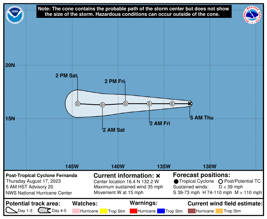
000
WTPZ32 KNHC 171450
TCPEP2

BULLETIN
Post-Tropical Cyclone Fernanda Advisory Number  20
NWS National Hurricane Center Miami FL       EP072023
500 AM HST Thu Aug 17 2023

...FERNANDA BECOMES A REMNANT LOW...
...THIS IS THE LAST NHC ADVISORY...


SUMMARY OF 500 AM HST...1500 UTC...INFORMATION
----------------------------------------------
LOCATION...16.4N 132.2W
ABOUT 1515 MI...2440 KM WSW OF THE SOUTHERN TIP OF BAJA CALIFORNIA
MAXIMUM SUSTAINED WINDS...35 MPH...55 KM/H
PRESENT MOVEMENT...W OR 270 DEGREES AT 15 MPH...24 KM/H
MINIMUM CENTRAL PRESSURE...1005 MB...29.68 INCHES


WATCHES AND WARNINGS
--------------------
There are no coastal watches or warnings in effect.


DISCUSSION AND OUTLOOK
----------------------
At 500 AM HST (1500 UTC), the center of Post-Tropical Cyclone
Fernanda was located near latitude 16.4 North, longitude 132.2 West.
The post-tropical cyclone is moving toward the west near 15 mph (24
km/h) and this general motion is expected to continue for the next
few days.

Maximum sustained winds have decreased to near 35 mph (55 km/h) with
higher gusts. Continued weakening is forecast during the next couple
of days, and Fernanda is likely to dissipate by the weekend.

The estimated minimum central pressure is 1005 mb (29.68 inches).


HAZARDS AFFECTING LAND
----------------------
None


NEXT ADVISORY
-------------
This is the last public advisory issued by the National Hurricane
Center on this system.

$$
Forecaster Bucci
Public Advisory not available for this storm.
Post-Tropical Cyclone FERNANDA Forecast Discussion
190
WTPZ42 KNHC 171450
TCDEP2

Post-Tropical Cyclone Fernanda Discussion Number  20
NWS National Hurricane Center Miami FL       EP072023
500 AM HST Thu Aug 17 2023

Fernanda has lacked convective activity since yesterday evening and
is therefore considered a post-tropical cyclone.  With no
convective activity, Dvorak estimates are no longer a reliable
source for intensity guidance.  The initial intensity is lowered to
30 kt for this advisory largely based on the trend in geostationary
satellite imagery.  An occasional burst of convection is still
possible given 25-26 degrees C sea surface temperatures along the
forecast track of Fernanda. Model guidance indicates the cyclone
will continue to weaken in an increasingly dry and stable
environment for the next few days and is likely to dissipate by
day 3.

The remnant low is moving westward at 13 kt.  This general motion
is expected to continue for the next few days as the system is
steered by the low-level flow around a ridge to its north.

For additional information on the remnant low please see High
Seas Forecasts issued by the National Weather Service.  Those
forecasts can be found under AWIPS header NFDHSFEPI and WMO
header FZPN02 KWBC, and on the web at
ocean.weather.gov/shtml/NFDHSFEPI.php.


FORECAST POSITIONS AND MAX WINDS

INIT  17/1500Z 16.4N 132.2W   30 KT  35 MPH...POST-TROPICAL
 12H  18/0000Z 16.4N 134.1W   25 KT  30 MPH...POST-TROP/REMNT LOW
 24H  18/1200Z 16.4N 136.6W   25 KT  30 MPH...POST-TROP/REMNT LOW
 36H  19/0000Z 16.4N 139.2W   25 KT  30 MPH...POST-TROP/REMNT LOW
 48H  19/1200Z 16.3N 141.7W   20 KT  25 MPH...POST-TROP/REMNT LOW
 60H  20/0000Z 16.4N 144.4W   20 KT  25 MPH...POST-TROP/REMNT LOW
 72H  20/1200Z...DISSIPATED

$$
Forecaster Bucci
FERNANDA storm path from NHC
| Time | Speed | Location | Status |
|---|---|---|---|
| 30 knots | 16.4, -132.2 | translation missing: en.POST-TROPICAL | |
| 25 knots | 16.4, -134.1 | POST-TROPICAL CYCLONE | |
| 25 knots | 16.4, -136.6 | POST-TROPICAL CYCLONE | |
| 25 knots | 16.4, -139.2 | POST-TROPICAL CYCLONE | |
| 20 knots | 16.3, -141.7 | POST-TROPICAL CYCLONE | |
| 20 knots | 16.4, -144.4 | POST-TROPICAL CYCLONE | |
| 0 knots | translation missing: en.DISSIPATED |
site by Hayley Croft
Want to help support this site?
- Tell your friends about Cyclocane
- make a donation - totally optional but completely appreciated
Make a monthly donation or a one-time donation to help support ongoing costs with Cyclocane.
Play solitaire and track all of the cyclocane storms at the same time at Hurricane Solitaire.