Cyclocane
( cyclocane is a CYCLOne and hurriCANE tracker by hayley )


English Español Deutsch Français 日本語
Esta es la ultima advertencia sobre esta sistema.
Visita la página de inicio para ver ciclones tropicales activos.
CINDY condiciones actuales
Vientos Ahora 35 knots / 40 MPH
Vientos Máximos 35 knots / 40 MPH at

Vigilancias/Avisos / Radares / Satélite
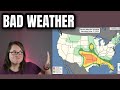
current US watches/warnings

live tornado/thunderstorm tracker - tornadohq
future radar imagery - my future radar

future radar imagery

(above image is an example of the Western North Atlantic page - see Atlantic future radar page for a full set of images)
If a tropical storm or hurricane is threatening land, you can check my future radar for an idea of what radar might look like as the storm approaches.
CINDY peligros afectando tierra
NWS Local Hurricane Statements
- No warnings
Datos en español no disponsibles, pero por la advertencia de inglés, los peligros son:
Visita la página inglés para más información
trayectoria del huracán CINDY
imágenes de satélite de CINDY
mapa de CINDY de NHC
CINDY modelos numéricos
En inglés lo que se conoce como "spaghetti models". Creo que el equivalente en español sería "modelo numérico de predicción".
CINDY modelo numérico de predicción (en inglés) »
CINDY vigilancias y aviso

huracan CINDY aviso publico
668
WTCA44 TJSJ 260249
TCPSP4

BOLETÍN
Remanentes de Cindy Advertencia Número 16
Centro Nacional de Huracanes del SNM Miami FL AL042023
Traducción Revisada por el SNM en San Juan PR
1100 PM AST domingo 25 de junio de 2023

...CINDY SE DEGENERA A UNA ONDA ABIERTA...
...ESTA ES LA ÚLTIMA ADVERTENCIA...


RESUMEN DE LAS 1100 PM AST...0300 UTC...INFORMACIÓN
-----------------------------------------------
LOCALIZACIÓN...22.8N 60.0O
ALREDEDOR DE 375 MI...605 KM NNE DE LAS ISLAS DE SOTAVENTO DEL NORTE
VIENTOS MÁXIMOS SOSTENIDOS...40 MPH...65 KM/H
MOVIMIENTO ACTUAL...NO O 315 GRADOS A 14 MPH...22 KM/H
PRESIÓN CENTRAL MÍNIMA...1011 MB...29.86 PULGADAS


VIGILANCIAS Y AVISOS
--------------------
No hay vigilancias ni avisos costeros en efecto.


DISCUSIÓN Y PERSPECTIVAS
----------------------
A las 1100 PM AST (0300 UTC), los remanentes de Cindy estaban
localizados cerca de la latitud 22.8 Norte, longitud 60.0 Oeste.
Los remanentes se están moviendo hacia el noroeste a cerca de 14 mph
(22 km/h) y se espera un movimiento hacia el noroeste con una
disminución gradual en la velocidad de traslación durante el próximo
día.

Los vientos máximos sostenidos están cerca de 40 mph (65 km/h) con
ráfagas más fuertes. Se pronostica un debilitamiento, y los vientos
deben caer por debajo de la fuerza de tormenta tropical más tarde
esta noche.

Los vientos con fuerza de tormenta tropical se extienden hacia el
exterior hasta 70 millas (110 km) hacia el noreste de los remanentes
del centro.

La presión central mínima estimada es de 1011 milibares...29.86
pulgadas.


PELIGROS AFECTANDO TIERRA
----------------------
Ninguno


PRÓXIMA ADVERTENCIA
-------------
Esta es la última advertencia pública emitida por el Centro Nacional
de Huracanes sobre este sistema. Se puede encontrar información
adicional en los Pronósticos de Alta Mar emitidos por el Servicio
Nacional de Meteorología, bajo el encabezado NFDHSFAT1 de AWIPS, el
encabezado FZNT01 KWBC de WMO y en línea a través de
ocean.weather.gov/shtml/NFDHSFAT1.php

$$
Pronosticador Beven
CINDY discusión
No disponible en español.
CINDY datos de NHC
| Tiempo | Viento | Localizacion | status |
|---|---|---|---|
| 35 nudos | 22.8, -60.0 | ||
| 0 nudos | translation missing: es.DISSIPATED |
site by Hayley Croft
- Tell your friends about Cyclocane
- make a donation - totally optional but completely appreciated
Make a monthly donation or a one-time donation to help support ongoing costs with Cyclocane.
Play solitaire and track all of the cyclocane storms at the same time at Hurricane Solitaire.